RAN snapshot · Șureanu study box
…
Official RAN site records, all periods, in the map's study box. Loading stored snapshot…
Source: CIMEC RAN GIS (layer 0), cached monthly.
Sites & Maps
Starting the 3D model… your choices will be applied when it is ready.
GDTHF project model (revision 8). 14 m full rises are restored scenario estimates; central plan cores retained, other citadel cores schematic. Markers are reference positions on the model, not proof of the displayed hypothesis; RAN markers are generalized ~2 km cells, never exact site positions.
2D research map
search area ±1–3 kmRAN ~2–4.5 km cellnot GPS · not terraces
Basemap caveat: satellite imagery has mixed capture dates and resolution and is not LiDAR; terrain relief is ~30 m SRTM. Credits for each basemap appear on the map. Imagery and map tiles are third-party services used under their providers' own terms (Esri, OpenTopoMap, OpenStreetMap); usage rights and required credits depend on those terms, and OpenStreetMap tiles are loaded only on demand in line with its tile usage policy (no bulk or offline downloading). Pre-launch note: the production-scale imagery provider and its terms must be verified before public launch.
Map evidence summary
These numbers use different units and cannot be added, subtracted or turned into percentages.
>4,000
LiDAR-identified terrace platforms (Fig. 10a, regional aggregate)
c.177
excavated / trial-trenched points (Fig. 6, mixed units)
c.158
survey-confirmed points (Fig. 6, mixed units)
>250
architectural-platform anomalies (Fig. 12, not confirmed houses)
—
official RAN records in the stored monthly snapshot (all periods; not terraces)
RAN-to-terrace exact intersection: unknown because terrace geometries are absent.
| Sector | Current | Earlier |
|---|---|---|
| Grădiștii Hill | c.373 | c.430 (earlier LiDAR count) |
| Fețele Albe | c.200 | 20–30 (older estimate) |
Published estimates (Pețan 2026), not GDTHF counts.
Original figures
Earlier maps & atlas
Known discoveries vs the terraced landscape
These counts measure different things over different areas. They are shown side by side and are never added together or turned into an overlap percentage.
RAN snapshot · Șureanu study box
…
Official RAN site records, all periods, in the map's study box. Loading stored snapshot…
Source: CIMEC RAN GIS (layer 0), cached monthly.
Planning study · two communes
94 · 28
Orăștioara de Sus commune: 94; Boșorod commune: 28. All periods, whole commune territory — administrative totals, not overlap. County: 1,026.
Pețan 2026 · high-altitude core
≈335
177 excavated or trial-trenched + 158 survey-verified investigation points. Not 335 distinct terraces, not necessarily 335 RAN sites.
Pețan 2026 · LiDAR
more than 4,000
Anthropogenic terrace features mapped from LiDAR (regional total). Individual positions not published.
Exact RAN sites ∩ terrace feature geometry: not yet computable. The original GIS of the more than 4,000 individual features is not available, so the overlap is unknown — not zero.
0 of 21 dated from official RAN component fields; the rest inferred from the record title (caveat). A record with several phases counts in each.
Registration precision: 11 located (COORD DA), 10 approximate locality (COORD NU). 0 records list research seasons on their RAN card.
Generalized RAN records whose ~2 km cell centre lies within 3 km of each study-sector centre (cells may count for neighbouring sectors). Shows co-location with the terraced core, not intersection with terraces.
RAN COORD: 11 DA, 10 NU. An official boundary (CIMEC RAN polygon layer) is matched by RAN code for 6 records; 0 of those touch a broad published terrace-study zone (1.5 km around the sector centre). That is an area comparison only — exact overlap with the more than 4,000 terraces remains unknown. Locality-centre records are not individual site positions. Only UNESCO-listed components are drawn with their boundary; all other boundaries are used on the server for counts and never published.
RAN 88500.02 · Late Iron Age / Dacian (RAN component dating (official card))
Luncani – Piatra Roșie
Record title only — RAN card details not yet retrieved; detailed finds not provided
RAN 88500.07 · Late Iron Age / Dacian (RAN component dating (official card))
Luncani – Vârful Străin
Record title only — RAN card details not yet retrieved; detailed finds not provided
RAN 88500.08 · Late Iron Age / Dacian (RAN component dating (official card))
Luncani – Poiana Omului
Record title only — RAN card details not yet retrieved; detailed finds not provided
RAN 88537.01 · Late Iron Age / Dacian (RAN component dating (official card))
Târsa – Vârful Secului
Record title only — RAN card details not yet retrieved; detailed finds not provided
RAN 88537.06 · Roman (RAN component dating (official card))
Târsa – Platoul Târsa
Record title only — RAN card details not yet retrieved; detailed finds not provided
RAN 90379.01 · Late Iron Age / Dacian (RAN component dating (official card))
Costești – Cetățuie
Record title only — RAN card details not yet retrieved; detailed finds not provided
RAN 90379.02 · Late Iron Age / Dacian (RAN component dating (official card))
Costești – Cetățuia Înaltă
Record title only — RAN card details not yet retrieved; detailed finds not provided
RAN 90379.05 · Late Iron Age / Dacian (RAN component dating (official card))
Costești – Blidaru
Record title only — RAN card details not yet retrieved; detailed finds not provided
RAN 90379.07 · Late Iron Age / Dacian (RAN component dating (official card))
Costești – Dârlău
Record title only — RAN card details not yet retrieved; detailed finds not provided
RAN 90379.08 · Late Iron Age / Dacian (RAN component dating (official card))
Costești – Merișorul
Record title only — RAN card details not yet retrieved; detailed finds not provided
RAN 90379.12 · Late Iron Age / Dacian (RAN component dating (official card))
Costești – Biserică / Gruiul Negru
Record title only — RAN card details not yet retrieved; detailed finds not provided
RAN 90379.13 · Late Iron Age / Dacian (RAN component dating (official card))
Costești – La Curți
Record title only — RAN card details not yet retrieved; detailed finds not provided
Already investigated vs mapped by LiDAR
In the high-altitude core, Pețan (2026) reports about 177 excavated or trial-trenched points and about 158 further points verified by surface survey — some 335 investigation points in all.
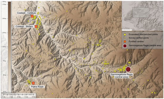
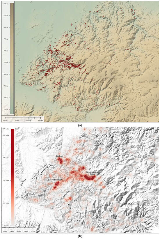
What the 335 are
Investigation points from more than a century of fieldwork. Mixed units: some points are individual terraces, others terrace groups, others broader investigated sectors. They are not 335 distinct RAN sites, and their individual coordinates are not published as data.
Dating
In this mountainous zone the archaeologically investigated record belongs exclusively to the Late Iron Age; earlier or later habitation is documented only in the lower valleys and adjacent low-altitude sectors. Most individual terraces have not been excavated and cannot be dated independently; their Dacian attribution is contextual, resting on association with directly dated sites.
How this map uses them
Not at all as dots. Figure 6 is shown as published and is not georeferenced or traced onto the map. The strongest high-altitude evidence is securely Late Iron Age, but not every one of the >4,000 terraces has been excavated.
Source: Aurora Pețan (2026), Humans 6(2), 19, https://doi.org/10.3390/humans6020019. © 2026 Aurora Pețan. Reproduced unmodified (reduced size) from Humans 6(2), 19 under CC BY 4.0. Licence.
Methodology
Official UNESCO references. The six components of World Heritage property 906, at the reference positions published by the UNESCO World Heritage Centre (DMS converted to WGS84). They mark each component as a whole, not a wall or gate. Listing is a heritage designation and implies no partnership. Sarmizegetusa Regia (Dacian) is not Ulpia Traiana Sarmizegetusa (Roman colony), which is outside this map's evidence layers.
Published study sectors. Approximate site-level centres of areas discussed in Pețan 2023, Pețan 2026 and Pețan & Hegyi 2023. The dashed circles are illustrative inspection zones, not excavated boundaries. No walls are drawn because none are georeferenced in the public record. The published aggregate of about 250 architectural anomalies is likewise not plotted.
RAN archaeological inventory. The National Archaeological Repertory (RAN, CIMEC) lists roughly 29,000 sites across Romania; it is a different dataset from the terraces. Twenty-one individual site records in Grădiștea de Munte, Costești, Luncani and Târsa were cross-checked code by code against the official entries and the official RAN map service; for heritage protection every RAN record, live or cross-checked, is generalized to a ~2 km grid cell and shown only as a numbered bubble listing codes and official links. The monthly sync generalizes positions before storing them, so precise RAN geometry is neither stored nor sent to the browser. The c. 250 architectural anomalies are not plotted, and the 76 visual samples are stored rounded to ~1 km. These are registry entries for sites, not excavation campaigns. For scale, the Hunedoara County planning study lists 94 RAN sites in Orăștioara de Sus and 28 in Boșorod (all periods, whole communes) and 1,026 in the county; these are shown as illustrative area circles, not boundaries. All records come from a stored snapshot of the official CIMEC map service for the Șureanu box, refreshed monthly (never fetched live while you move the map), with the RAN COORD field shown unchanged: per CIMEC, located points (DA) are site centres and approximate points (NU) are locality centres, not exact positions. The older RAN text for Fețele Albe (c. 20 terraces, approximately located) predates the LiDAR estimate of c. 200 terraces. RAN is incomplete in high-altitude terrain; absence of a record is not absence of remains.
Low-confidence visual samples. 76 points hand-estimated from Pețan 2026, Fig. 10(a), an image without registration. Their error is often 1–3 km or more. They do not reproduce or georeference that figure, and the more than 4,000 terraces it reports are a regional total, not 76 or 4,000 points here. No synthetic or simulated point set is used. Any future georeferencing of Fig. 10 would need control-point registration, a stated error estimate and the author's data permission.
Coordinate source / discrepancy
Older approximate positions used before this atlas have not been overwritten. Distances from those positions to the UNESCO references:
The Fețele Albe reference position comes from independent research and its provenance still needs verification.
Morphological signs vs confirmation. LiDAR shows shapes consistent with human terracing. Dating, function and phase need excavation, finds or field survey.
Privacy & anti-looting. We publish no precise positions for unknown or vulnerable archaeology, offer no directions, and accept no public submissions of find locations. Metal-detecting and unauthorised digging at these sites are illegal and destroy evidence; report damage to the site administration and local authorities.
Bibliography
Open access, CC BY 4.0. Reports about 177 excavated or trial-trenched points and about 158 surface-survey-verified points in the high-altitude core (Fig. 6; mixed units, all Late Iron Age), and separately more than 4,000 anthropogenic terraces as a regional aggregate. Fig. 10(a) shows their distribution; Fig. 10(b,c) show kernel-density maps at 300 m and 800 m. See the figures in the original article — they are not reproduced here.
Public abstract describes raised foundations of about 7–10 m, most concentrated around Grădiștii, Fețele Albe and Anineș. It gives no coordinates of individual platforms.
Method paper on the public LiDAR-derived terrain model used to identify terracing.
Official reference positions of the six inscribed components. A heritage listing, not a partnership.
National inventory of roughly 29,000 archaeological sites. It is not the source of the >4,000 terraces or of the 76 exploratory points. The inventory is incomplete in high-altitude terrain: absence of a RAN record is not absence of ancient remains.
Lists 94 RAN archaeological sites in Orăștioara de Sus commune and 28 in Boșorod (122 in two communes, all periods, whole commune territory) and 1,026 RAN sites in Hunedoara County. Not 122 Dacian sites and not 122 overlaps with the terrace distribution.
Map key: polygons are official boundaries; red points are site centres located geographically; green points are approximate locality-centre coordinates, not exact positions. This site stores a monthly snapshot of PatrimoniuWM layer 0 for the Șureanu box and shows only generalized ~2 km cells; it does not query the service while you browse.
Future source of high-resolution bare-earth LiDAR. Raster files have NOT been ingested; no LiDAR comparison is shown.
Beyond the core
Broad public locations only. We do not publish coordinates for vulnerable sites.
Late Iron Age
Sebeș valley, Alba County
UNESCO-listed fortress at the eastern edge of the Orăștie system; current interdisciplinary research.
Official page checked · Ongoing project; not a final interpretation.
Official page checked · Preliminary field report.
Late Iron Age
Cugir, Alba County
Hilltop fortress and habitation outside the UNESCO listing; campaigns 2023–2024.
Official page checked · Preliminary field report.
Official page checked · Campaign-level reporting; cite individual site entries when possible.
Late Iron Age
Ocnele Mari, Vâlcea County
Settlement with a funerary landscape now being re-interpreted.
Official page checked · Interpretations of pit function have been revised by later campaigns.
Official page checked · Argues many pits belong mainly to a funerary horizon; applies to this site only.
DOI metadata checked · Site-specific cremation evidence.
Bronze Age – Late Iron Age
Arad County
Multi-period fortified settlement on the Mureș.
Identification with Ziridava is proposed, not secure.
Official page checked · Pecica = ancient Ziridava is a longstanding hypothesis, not a certainty.
Late Iron Age
Galați County
Settlement with glass finds studied by archaeometry.
Traditionally identified with Piroboridava; identification proposed.
DOI metadata checked · Imported raw glass or vessels do not imply Roman political control.
Late Iron Age
Hunedoara County
Fortress where a Roman bronze saucepan points to pre-conquest imports.
DOI metadata checked · One object; trade route details are interpretive.
Late Iron Age
Sibiu County
Regional fortress known mainly from 1960s excavation.
DOI metadata checked · Older interpretive framework; read historiographically.
Roman Dacia
Alba Iulia, Alba County
Legionary base and towns; graves, villa and a large religious catalogue.
Official page checked · Some statements are preliminary project interpretation.
DOI metadata checked · Old excavation; one cemetery.
Publisher/journal metadata checked · 638-object catalogue: evidence for Roman-period religious diversity, not pre-conquest Dacian religion.
Roman Dacia
Turda, Cluj County
Legionary fortress with excavated kitchens and a civilian settlement.
DOI metadata checked · One legionary fortress.
Official page checked · Current campaign summary.
Roman Dacia
Sălaj County
Frontier fort and municipium; praetorium and baths under study.
Official page checked · Project summary; ongoing.
Publisher/journal metadata checked · Porolissum evidence is local and Roman-period, not a universal pre-conquest diet.
Roman Dacia
Alba County
UNESCO Roman mining landscape; wax-tablet contracts.
Official page checked · Heritage summary; not a full excavation record.
DOI metadata checked · Network reconstruction from a limited tablet corpus.
Thracian & Lower Danube
Broad public locations only. We do not publish coordinates for vulnerable sites.
Late 4th – 3rd c. BCE
Kazanlak valley (now under a reservoir)
Thracian royal town; its Greek inscription records oaths and arrangements.
DOI metadata checked · Challenges simple “Hellenization” narratives.
4th – 3rd c. BCE
Razgrad Province, NE Bulgaria
Getic fortified centre and tomb landscape in the Lower Danube.
Publisher/journal metadata checked · Site-specific urban interpretation; verify exact original title.
Visiting responsibly
Do not use metal detectors, move stones or collect finds. Report damage or suspected looting to the site administration and local authorities.